


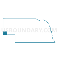
Dix Precinct, Kimball County, Nebraska
About
Outline

Summary
| Unique Area Identifier | 613331 |
| Name | Dix Precinct |
| County | Kimball County |
| State | Nebraska |
| Area (square miles) | 263.04 |
| Land Area (square miles) | 263.04 |
| Water Area (square miles) | 0.00 |
| % of Land Area | 100.00 |
| % of Water Area | 0.00 |
| Latitude of the Internal Point | 41.20179950 |
| Longtitude of the Internal Point | -103.47065460 |
Maps


Graphs
Select a template below for downloading or customizing gragh for Dix Precinct, Kimball County, Nebraska


Neighbors
Neighoring Voting District (by Name) Neighboring Voting District on the Map
- Antelope Precinct, Kimball County, NE
- Logan 12, Logan County, CO
- Long Springs Precinct, Banner County, NE
- Potter Precinct, Cheyenne County, NE
Top 10 Neighboring County Subdivision (by Population) Neighboring County Subdivision on the Map
- Long Springs precinct, Banner County, NE (690)
- Potter precinct, Cheyenne County, NE (644)
- Antelope precinct, Kimball County, NE (588)
- Peetz CCD, Logan County, CO (515)
- Dix precinct, Kimball County, NE (434)
Top 10 Neighboring Place (by Population) Neighboring Place on the Map
Top 10 Neighboring Unified School District (by Population) Neighboring Unified School District on the Map
- Kimball Public Schools, NE (3,423)
- Potter-Dix Public Schools, NE (1,051)
- Banner County Public Schools, NE (747)
- Plateau School District RE-5, CO (532)
Top 10 Neighboring State Legislative District Lower Chamber (by Population) Neighboring State Legislative District Lower Chamber on the Map
Top 10 Neighboring State Legislative District Upper Chamber (by Population) Neighboring State Legislative District Upper Chamber on the Map
Top 10 Neighboring 111th Congressional District (by Population) Neighboring 111th Congressional District on the Map
Top 10 Neighboring Census Tract (by Population) Neighboring Census Tract on the Map
- Census Tract 9545, Kimball County, NE (3,821)
- Census Tract 9548, Cheyenne County, NE (3,157)
- Census Tract 9659, Logan County, CO (1,090)
- Census Tract 9540, Banner County, NE (690)